Less than two weeks into its mission, Sentinel-2C satellite has already begun delivering breathtaking images of Earth, providing a glimpse of the valuable data it will contribute to Copernicus, Europe’s renowned Earth observation program.
Sentinel-2C satellite
In the early hours of 5 September, European time, the third satellite in the Copernicus Sentinel-2 series was launched into space from Europe’s Spaceport in French Guiana aboard the last Vega rocket.
Just like its predecessor satellites, Sentinel-2A and Sentinel-2B, Sentinel-2C is equipped with a multispectral camera that captures high-resolution images of Earth’s landscape, islands, and both inland and coastal waters from an orbital altitude of 786 km.
Earth’s landscape from Sentinel-2C
The satellite’s powerful multispectral imager boasts an impressive swath width of 290 km, capturing continuous, high-resolution imagery across 13 distinct spectral bands, with resolutions of 10 m, 20 m, and 60 m.
Seville, the capital of Andalusia, lies on the Guadalquivir River, one of the longest rivers in Spain. Credit: Sentinel 2C/ESA
This capability allows it to monitor vast areas with remarkable detail, offering invaluable data for environmental monitoring and disaster management.
Within just a week of its launch, Sentinel-2C had already acquired an array of vibrant, detailed images from diverse regions across the globe, showcasing the satellite’s versatility and precision in Earth observation.
Images inscribed in light
One of the early images features the clear view of Seville and its surroundings in southern Spain.
Another image offers a lengthy strip that stretches from Camargue and Montpellier in southern France all the way down to the south of Barcelona in Spain.
A long strip that stretches from the Camargue and Montpellier in southern France all the way down to south of Barcelona in Spain. Credit: Sentinel 2C/ESA
Venturing beyond Europe, Sentinel-2C satellite also captured an area south of Los Angeles in California, revealing one of the raging wildfires.
The satellite uses different bands from the multispectral imager to highlight natural color images and false color images of the wildfires, allowing us to see both the extent of the burn area and the active fires, depicted as bright orange spots in the images.
Tranquil beauty in blue
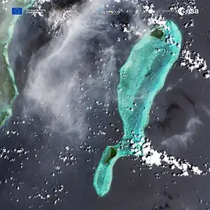
A more peaceful satellite image features the Lighthouse Reef, part of the vast coral reef system off the coast of Belize in Central America.
A renowned site, the Great Blue Hole — a giant marine sinkhole — can be visibly observed in these images.
 Lighthouse Reef, part of the large coral reef system off the coast of Belize in Central America. Here the famous Great Blue Hole can be seen – a giant marine sinkhole. Credit: Sentinel 2C/ESA
“These initial images stand as a powerful testament to the success of this extraordinary mission. While Sentinel-2 will continue to serve Copernicus with distinction for years to come, we are already looking ahead as we develop the next chapter with the Sentinel-2 Next Generation mission.” said Simonetta Cheli, ESA’s Director of Earth Observation Programmes.
Promising start for Sentinel-2C
Following its successful launch, Sentinel-2C’s multispectral imager will undergo calibration as part of the commissioning phase, which will last approximately three months.
Despite being early in its mission, the quality delivered by Sentinel-2C has already exceeded expectations.
Sentinel-2C’s commissioning activities run alongside the routine operations of its sister satellites Sentinel-1, Sentinel-2, Sentinel-3 for land, and Sentinel-5P.
Data by Sentinel-2 satellites
The data provided by the Sentinel-2 satellites and other Copernicus missions managed by ESA are freely available through the Copernicus Data Space Ecosystem.
Once fully commissioned, data from the new ‘C’ satellite will also be accessible to users.
“We are thrilled to see the Copernicus Sentinel-2C already capturing such breathtaking images of Earth so soon after its launch. This is just the beginning of the incredible insights and detailed data it will provide, helping us better understand our planet,” noted Constantin Mavrocordatos, Sentinel-2 Project Manager at ESA.
“It is truly remarkable how well the multispectral instrument had been calibrated even before the satellite was launched, producing such stunning first images,” added Francisco Reina, Sentinel-2 Payload Manager.
“This achievement is the result of an outstanding collaboration between ESA and the Airbus teams throughout the instrument’s development phase.”
Applications of the Sentinel-2 satellites
The data generated by the Copernicus Sentinel-2 satellites are utilized in a wide array of applications.
The Sentinel-2 mission is crucial to the Copernicus program, which focuses on Earth observation for various applications, including agriculture, water quality monitoring, and natural disaster management like wildfires, volcanic eruptions, and floods.
With satellites like the Sentinel-2C, we’re not just monitoring our planet—we’re understanding it, piece by piece, image by image. They help us in staying a step ahead in environmental conservation and disaster management.
—–
Like what you read? Subscribe to our newsletter for engaging articles, exclusive content, and the latest updates.
Check us out on EarthSnap, a free app brought to you by Eric Ralls and Earth.com.
—–
Author :
Publish date : 2024-09-23 10:04:00
Copyright for syndicated content belongs to the linked Source.
—-
Author : theamericannews
Publish date : 2024-09-23 21:55:15
Copyright for syndicated content belongs to the linked Source.